10 year anniversary of the 2011 floods
Published on 14 January 2021
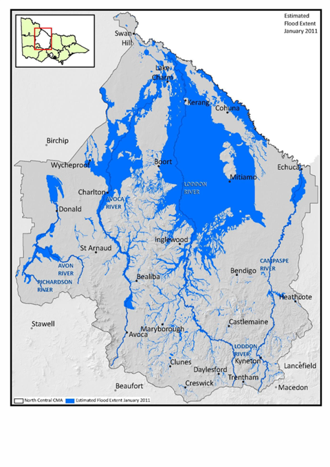
This week marks the 10 year anniversary of the January 2011 flood event; the second largest in recorded history and significantly bigger than the September and December events in 2010. Written records indicate that its magnitude was exceeded only by the floods of 1909.
The fast flowing flood travelled north from the upper reaches of the Loddon River, the Bullock Creek and Bendigo Creek, from outside the Shire. Newbridge was the first town affected, followed by Bridgewater. The flood waters then moved further north along the Loddon River dispersing into creeks and anabranches as it traversed the northern floodplains to eventually enter the Murray River system.
At the flood’s peak, water volumes recorded at the Laanecoorie Reservoir spillway reached 194 gigalitres per day. To put this volume into context, Melbourne uses 460 gigalitres of water per year.
Over 30% (approx 2,200 sq km) of the Shire was impacted. At its peak, the flood was reported to be 90 km long and 50 km wide.
Many farms and towns were directly impacted. The flood progressively caused dislocation and isolation of many parts of the Shire with the flood waters cutting roads (including the Calder Highway and the Loddon Valley Highway for several days). Subsequent damage assessments confirmed approximately $30 million damage was caused to Council managed infrastructure alone.
We join those members of our community who will take some this week to reflect on the event, which delivered many challenges but also demonstrated the strength and resilience of our people and communities as they dealt with and then recovered from the impacts of the flood.
We know that many members of our community were impacted by the 2011 Floods. If reflecting on the event at this time causes you to experience an emotional or physical reaction, we encourage you to contact your doctor, mental health professional or Lifeline on 13 11 14.